


platiton

thle
User
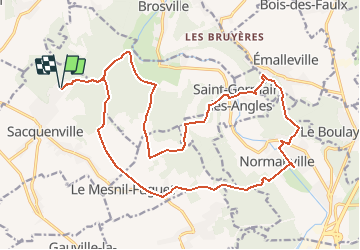

Length
22 km

Max alt
149 m

Uphill gradient
457 m
Km-Effort
28 km

Min alt
42 m

Downhill gradient
457 m
Boucle
Yes
Creation date :
2015-12-12 00:00:00.0
Updated on :
2015-12-12 00:00:00.0
5m
Difficulty : Medium

FREE GPS app for hiking
 SityTrail
IGN / Geographical institutes
SityTrail Plus
The world is yours!
About
Trail Other activity of 22 km to be discovered at Normandy, Eure, Sacquenville. This trail is proposed by thle.
Description
Plateau et Vallée de l'Iton
Positioning
Country:
France
Region :
Normandy
Department/Province :
Eure
Municipality :
Sacquenville
Location:
Unknown
Start:(Dec)
Start:(UTM)
359838 ; 5439551 (31U) N.
Comments