


20151215 franqueville odile

doudet
User
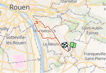

Length
11.4 km

Max alt
165 m

Uphill gradient
190 m
Km-Effort
13.9 km

Min alt
6 m

Downhill gradient
190 m
Boucle
Yes
Creation date :
2018-09-11 09:12:00.124
Updated on :
2018-09-11 09:12:00.124
2h50
Difficulty : Medium

FREE GPS app for hiking
 SityTrail
IGN / Geographical institutes
SityTrail Plus
The world is yours!
About
Trail Walking of 11.4 km to be discovered at Normandy, Seine-Maritime, Le Mesnil-Esnard. This trail is proposed by doudet.
Positioning
Country:
France
Region :
Normandy
Department/Province :
Seine-Maritime
Municipality :
Le Mesnil-Esnard
Location:
Unknown
Start:(Dec)
Start:(UTM)
365939 ; 5474273 (31U) N.
Comments