Trail Walking Saint-Estève - 66 ST-ESTEVE, à PERPIGNAN-Bas Vernet par Le centre ville, la Colomina et l'espace St-Mamet - Photo

66 ST-ESTEVE, à PERPIGNAN-Bas Vernet par Le centre ville, la Colomina et l'espace St-Mamet

 jeff66
jeff66

User

© OpenStreetMap contributors
Length
Length
14.2 km
Max alt
Max alt
49 m
Uphill gradient
Uphill gradient
76 m
Km-Effort
Km-Effort  
15.2 km
Min alt
Min alt
26 m
Downhill gradient
Downhill gradient
77 m
Boucle
Boucle
Yes
Creation date :
2015-12-18 00:00:00.0
Updated on :
2015-12-18 00:00:00.0

(0 Reviews)

Walking
Walking
2h23
Difficulty : Medium

Scan this QR Code to open this trail in the SityTrail application

FREE GPS app for hiking

Logo SityTrail SityTrail

IGN / Geographical institutes

Download SityTrail from the App Store Download SityTrail from Google Play

Logo SityTrail SityTrail World

The world is yours!

Download SityTrail from the App Store Download SityTrail from Google Play Download SityTrail on Huawei AppGallery

About

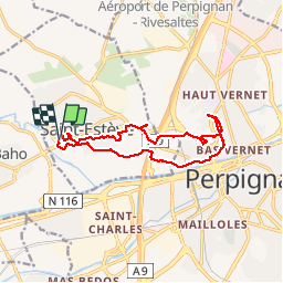
Trail Walking of 14.2 km to be discovered at Occitania, Pyrénées-Orientales, Saint-Estève. This trail is proposed by jeff66.

Description

66 ST-ESTEVE, à PERPIGNAN-Bas Vernet par Le centre ville, la Colomina et l'espace St-Mamet

Elevation profile

Photos

Positioning

Country:
France
Region :
Occitania
Department/Province :
Pyrénées-Orientales
Municipality :
Saint-Estève
Location:
Unknown
Start:(UTM)
486703 ; 4728332 (31T) N.

Trails nearby

Trail Walking Saint-Estève - SAINT-ESTEVE 66 - ballade dans le Vignoble de Rivesaltes  - Photo
Walking
jeff66

Walking

Medium
(1)
Saint-Estève, Occitania, Pyrénées-Orientales, France
8 km | 8.8 km-effort
1h 23min
Yes
Trail Walking Perpignan - Perpignan 01.10.2017  - Photo
Walking
jeff66

Walking

Easy
(1)
Perpignan, Occitania, Pyrénées-Orientales, France
6.7 km | 7.5 km-effort
1h 39min
No
Trail Walking Perpignan - canal Perpignan  - Photo
Walking
Fildesir

Walking

Very easy
Perpignan, Occitania, Pyrénées-Orientales, France
25 km | 27 km-effort
7h 29min
No
Trail Walking Perpignan - 66 Perpignan Panchot centre bas Vernet centre del mon - Photo
Walking
jeff66

Walking

Easy
Perpignan, Occitania, Pyrénées-Orientales, France
8.6 km | 9.3 km-effort
1h 29min
Yes
Trail Walking Perpignan - Xxx - Photo
Walking
jeff66

Walking

Medium
Perpignan, Occitania, Pyrénées-Orientales, France
15.1 km | 16.9 km-effort
2h 26min
Yes
Trail Walking Perpignan - 66 PERPIGNAN polygone nord au Haut Vernet - Photo
Walking
jeff66

Walking

Medium
Perpignan, Occitania, Pyrénées-Orientales, France
10.4 km | 11 km-effort
1h 57min
Yes
Trail Walking Perpignan - 66 PERPIGNAN, du sud au Nord Et retour - Photo
Walking
jeff66

Walking

Medium
Perpignan, Occitania, Pyrénées-Orientales, France
13.8 km | 15.4 km-effort
2h 40min
Yes
Trail Walking Perpignan - 66 PERPIGNAN porte Espagne, les arcades, saint Martin, moulin à vent, vertefeuille, mas Gaffard - Photo
Walking
jeff66

Walking

Medium
Perpignan, Occitania, Pyrénées-Orientales, France
10.3 km | 11.7 km-effort
1h 48min
Yes
Trail Walking Baho - 66 SAINT-ESTEVE, promenade entre jardins, canaux et centre ville - Photo
Walking
jeff66

Walking

Easy
Baho, Occitania, Pyrénées-Orientales, France
6.9 km | 7.3 km-effort
1h 16min
Yes


Close
My subscriptions