


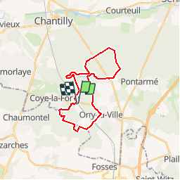
ORRY LA VILLE PAR LA BORNE BLANCHE

NUITEVEN
User

Length
22 km

Max alt
137 m

Uphill gradient
253 m
Km-Effort
26 km

Min alt
46 m

Downhill gradient
253 m
Boucle
Yes
Creation date :
2015-12-24 00:00:00.0
Updated on :
2015-12-24 00:00:00.0
5h40
Difficulty : Very easy

FREE GPS app for hiking
 SityTrail
IGN / Geographical institutes
SityTrail Plus
The world is yours!
About
Trail Walking of 22 km to be discovered at Hauts-de-France, Oise, Orry-la-Ville. This trail is proposed by NUITEVEN.
Positioning
Country:
France
Region :
Hauts-de-France
Department/Province :
Oise
Municipality :
Orry-la-Ville
Location:
Unknown
Start:(Dec)
Start:(UTM)
462821 ; 5443023 (31U) N.
Comments