


de vif à l'échaillon via uriol

maupassant38
User
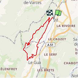

Length
13.6 km

Max alt
915 m

Uphill gradient
739 m
Km-Effort
23 km

Min alt
309 m

Downhill gradient
739 m
Boucle
Yes
Creation date :
2019-02-22 22:31:17.578
Updated on :
2019-02-22 22:31:17.617
4h45
Difficulty : Medium

FREE GPS app for hiking
 SityTrail
IGN / Geographical institutes
SityTrail Plus
The world is yours!
About
Trail Walking of 13.6 km to be discovered at Auvergne-Rhône-Alpes, Isère, Vif. This trail is proposed by maupassant38.
Positioning
Country:
France
Region :
Auvergne-Rhône-Alpes
Department/Province :
Isère
Municipality :
Vif
Location:
Unknown
Start:(Dec)
Start:(UTM)
710011 ; 4992608 (31T) N.
Comments