


Tour de l'aerodrome

ludol
User
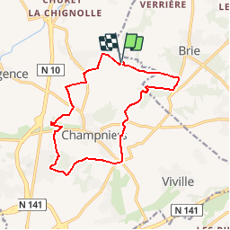

Length
14.6 km

Max alt
141 m

Uphill gradient
194 m
Km-Effort
17.2 km

Min alt
66 m

Downhill gradient
194 m
Boucle
Yes
Creation date :
2015-12-27 00:00:00.0
Updated on :
2015-12-27 00:00:00.0
2h17
Difficulty : Medium

FREE GPS app for hiking
 SityTrail
IGN / Geographical institutes
SityTrail Plus
The world is yours!
About
Trail Mountain bike of 14.6 km to be discovered at New Aquitaine, Charente, Champniers. This trail is proposed by ludol.
Description
Balade rigolote pour baptiser le nouveau vélo d'Ernerson.
Positioning
Country:
France
Region :
New Aquitaine
Department/Province :
Charente
Municipality :
Champniers
Location:
Unknown
Start:(Dec)
Start:(UTM)
283365 ; 5068286 (31T) N.
Comments