


TOURNETTE 1

UDGI54
User
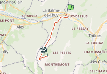

Length
7 km

Max alt
1727 m

Uphill gradient
1126 m
Km-Effort
18.8 km

Min alt
587 m

Downhill gradient
187 m
Boucle
No
Creation date :
2015-12-29 00:00:00.0
Updated on :
2015-12-29 00:00:00.0
5h00
Difficulty : Unknown

FREE GPS app for hiking
 SityTrail
IGN / Geographical institutes
SityTrail Plus
The world is yours!
About
Trail Other activity of 7 km to be discovered at Auvergne-Rhône-Alpes, Upper Savoy, Thônes. This trail is proposed by UDGI54.
Positioning
Country:
France
Region :
Auvergne-Rhône-Alpes
Department/Province :
Upper Savoy
Municipality :
Thônes
Location:
Unknown
Start:(Dec)
Start:(UTM)
289877 ; 5086439 (32T) N.
Comments