


LL34-Navacelles-Blandas

alainandrejoly
User
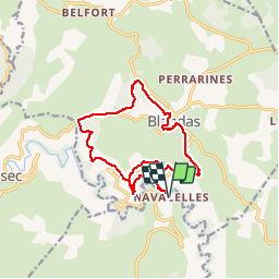

Length
16.1 km

Max alt
748 m

Uphill gradient
575 m
Km-Effort
24 km

Min alt
326 m

Downhill gradient
574 m
Boucle
Yes
Creation date :
2015-12-31 00:00:00.0
Updated on :
2015-12-31 00:00:00.0
4h59
Difficulty : Medium

FREE GPS app for hiking
 SityTrail
IGN / Geographical institutes
SityTrail Plus
The world is yours!
About
Trail Walking of 16.1 km to be discovered at Occitania, Hérault, Saint-Maurice-Navacelles. This trail is proposed by alainandrejoly.
Description
30/12/2015
Positioning
Country:
France
Region :
Occitania
Department/Province :
Hérault
Municipality :
Saint-Maurice-Navacelles
Location:
Unknown
Start:(Dec)
Start:(UTM)
541056 ; 4860262 (31T) N.
Comments