


île renote

theo89
User
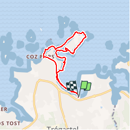

Length
6.2 km

Max alt
12 m

Uphill gradient
49 m
Km-Effort
6.9 km

Min alt
-1 m

Downhill gradient
48 m
Boucle
Yes
Creation date :
2016-01-01 00:00:00.0
Updated on :
2016-01-01 00:00:00.0
1h32
Difficulty : Very easy

FREE GPS app for hiking
 SityTrail
IGN / Geographical institutes
SityTrail Plus
The world is yours!
About
Trail Walking of 6.2 km to be discovered at Brittany, Côtes-d'Armor, Trégastel. This trail is proposed by theo89.
Positioning
Country:
France
Region :
Brittany
Department/Province :
Côtes-d'Armor
Municipality :
Trégastel
Location:
Unknown
Start:(Dec)
Start:(UTM)
463080 ; 5408008 (30U) N.
Comments