


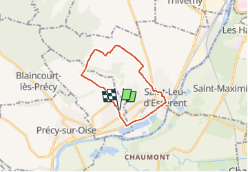
Villers sous Saint Leu_Trace_Gps simplifiée_9,7km

Pousscailleux
User

Length
9.7 km

Max alt
88 m

Uphill gradient
112 m
Km-Effort
11.1 km

Min alt
24 m

Downhill gradient
110 m
Boucle
Yes
Creation date :
2016-01-19 00:00:00.0
Updated on :
2022-11-28 14:04:24.067
2h27
Difficulty : Easy

FREE GPS app for hiking
 SityTrail
IGN / Geographical institutes
SityTrail Plus
The world is yours!
About
Trail Walking of 9.7 km to be discovered at Hauts-de-France, Oise, Villers-sous-Saint-Leu. This trail is proposed by Pousscailleux.
Description
St Leu par les Etangs, retour par le sud-est du Bois St Michel.
Positioning
Country:
France
Region :
Hauts-de-France
Department/Province :
Oise
Municipality :
Villers-sous-Saint-Leu
Location:
Unknown
Start:(Dec)
Start:(UTM)
456209 ; 5451287 (31U) N.
Comments