


PRESLES BOUCLE DANS LA FORET DE CARNELLE

NUITEVEN
User
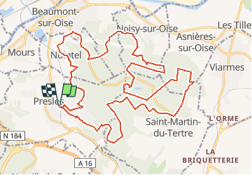

Length
27 km

Max alt
218 m

Uphill gradient
638 m
Km-Effort
36 km

Min alt
42 m

Downhill gradient
640 m
Boucle
Yes
Creation date :
2016-03-09 00:00:00.0
Updated on :
2020-02-14 17:04:47.729
7h34
Difficulty : Easy

FREE GPS app for hiking
 SityTrail
IGN / Geographical institutes
SityTrail Plus
The world is yours!
About
Trail Walking of 27 km to be discovered at Ile-de-France, Val-d'Oise, Presles. This trail is proposed by NUITEVEN.
Positioning
Country:
France
Region :
Ile-de-France
Department/Province :
Val-d'Oise
Municipality :
Presles
Location:
Unknown
Start:(Dec)
Start:(UTM)
447991 ; 5440294 (31U) N.
Comments