


LL34 Reculée de Claret-1

alainandrejoly
User
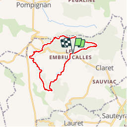

Length
12.9 km

Max alt
380 m

Uphill gradient
281 m
Km-Effort
16.6 km

Min alt
173 m

Downhill gradient
279 m
Boucle
Yes
Creation date :
2016-12-12 00:00:00.0
Updated on :
2016-12-12 00:00:00.0
3h52
Difficulty : Easy

FREE GPS app for hiking
 SityTrail
IGN / Geographical institutes
SityTrail Plus
The world is yours!
About
Trail Walking of 12.9 km to be discovered at Occitania, Hérault, Claret. This trail is proposed by alainandrejoly.
Description
31/01/2016
Crêtes de la montagne du Causse et de Taillade au départ des Embruscalles
Positioning
Country:
France
Region :
Occitania
Department/Province :
Hérault
Municipality :
Claret
Location:
Unknown
Start:(Dec)
Start:(UTM)
571031 ; 4857740 (31T) N.
Comments
Super randonnée. Paysage magnifique, les monotraces sont sublimes. La trace et parfois difficile à trouver.