


irancy 2016

theo89
User
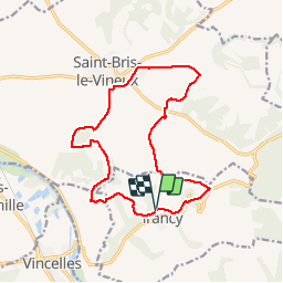

Length
14.9 km

Max alt
268 m

Uphill gradient
394 m
Km-Effort
20 km

Min alt
130 m

Downhill gradient
393 m
Boucle
Yes
Creation date :
2016-03-09 00:00:00.0
Updated on :
2016-03-09 00:00:00.0
2h55
Difficulty : Very easy

FREE GPS app for hiking
 SityTrail
IGN / Geographical institutes
SityTrail Plus
The world is yours!
About
Trail Walking of 14.9 km to be discovered at Bourgogne-Franche-Comté, Yonne, Irancy. This trail is proposed by theo89.
Positioning
Country:
France
Region :
Bourgogne-Franche-Comté
Department/Province :
Yonne
Municipality :
Irancy
Location:
Unknown
Start:(Dec)
Start:(UTM)
549739 ; 5284839 (31T) N.
Comments