


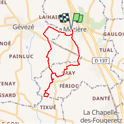
circuit de la riviere

eric.deniau
User

Length
13 km

Max alt
105 m

Uphill gradient
137 m
Km-Effort
14.8 km

Min alt
48 m

Downhill gradient
137 m
Boucle
Yes
Creation date :
2016-03-09 00:00:00.0
Updated on :
2016-03-09 00:00:00.0
3h13
Difficulty : Unknown

FREE GPS app for hiking
 SityTrail
IGN / Geographical institutes
SityTrail Plus
The world is yours!
About
Trail Other activity of 13 km to be discovered at Brittany, Ille-et-Vilaine, La Mézière. This trail is proposed by eric.deniau.
Positioning
Country:
France
Region :
Brittany
Department/Province :
Ille-et-Vilaine
Municipality :
La Mézière
Location:
Unknown
Start:(Dec)
Start:(UTM)
592427 ; 5341438 (30U) N.
Comments