


Levast0316

rollondesbois
User
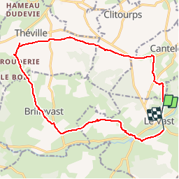

Length
16.2 km

Max alt
129 m

Uphill gradient
209 m
Km-Effort
19 km

Min alt
27 m

Downhill gradient
223 m
Boucle
No
Creation date :
2016-03-09 00:00:00.0
Updated on :
2016-03-09 00:00:00.0
4h00
Difficulty : Unknown

FREE GPS app for hiking
 SityTrail
IGN / Geographical institutes
SityTrail Plus
The world is yours!
About
Trail Other activity of 16.2 km to be discovered at Normandy, Manche, Le Vast. This trail is proposed by rollondesbois.
Positioning
Country:
France
Region :
Normandy
Department/Province :
Manche
Municipality :
Le Vast
Location:
Unknown
Start:(Dec)
Start:(UTM)
618651 ; 5498121 (30U) N.
Comments