


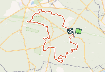
Fontainebleau: points de vue et rochers spectaculaires

bduche
User


4h51
Difficulty : Difficult

FREE GPS app for hiking
 SityTrail
IGN / Geographical institutes
SityTrail Plus
The world is yours!
About
Trail Walking of 24 km to be discovered at Ile-de-France, Seine-et-Marne, Fontainebleau. This trail is proposed by bduche.
Description
Balade qui conduit du Rocher des Princes au Carrosse, puis à la grotte Béatrix et au magnifique rempart du Restant du Long Rocher. Poursuite par le point de vue de l'Inspecteur général, puis par le rocher de Bouligny et le Rocher d'Avon. Très beau en hiver quand les sous-bois sont dégagés, ainsi que les points de vue.
Positioning
Comments