


Rando santé 2 - Courcelles les Gisors

marcel.F
User
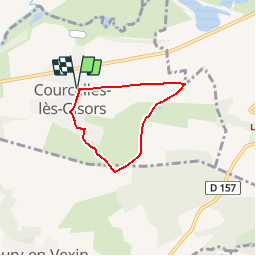

Length
4.3 km

Max alt
133 m

Uphill gradient
65 m
Km-Effort
5.1 km

Min alt
68 m

Downhill gradient
65 m
Boucle
Yes
Creation date :
2019-04-01 20:24:04.371
Updated on :
2019-04-05 20:28:06.807
1h30
Difficulty : Easy

FREE GPS app for hiking
 SityTrail
IGN / Geographical institutes
SityTrail Plus
The world is yours!
About
Trail Walking of 4.3 km to be discovered at Hauts-de-France, Oise, Courcelles-lès-Gisors. This trail is proposed by marcel.F.
Description
Parcours départ parking salle des fêtes de Courcelles les Gisors (60)
Positioning
Country:
France
Region :
Hauts-de-France
Department/Province :
Oise
Municipality :
Courcelles-lès-Gisors
Location:
Unknown
Start:(Dec)
Start:(UTM)
408569 ; 5457233 (31U) N.
Comments