![](/images/other/stat-length.png)
![Trail Walking Buysscheure - GR 130 : GR de L'Yser - Photo](https://media.geolcdn.com/t/1900/400/ext.pjpeg?maxdim=2&url=https%3A%2F%2Fstatic1.geolcdn.com%2Fsiteimages%2Fupload%2Ffiles%2F1553511878bg_sport_marche.png)
GR 130 : GR de L'Yser
Lecoester
User
![Length](/images/other/stat-length.png)
Length
55 km
![Max alt](https://static1.geolcdn.com/siteimages/upload/files/1508320355ic_sort_altitude_max_24dp.png)
Max alt
62 m
![Uphill gradient](https://static1.geolcdn.com/siteimages/upload/files/1508320355ic_sort_den_pos_24dp.png)
Uphill gradient
296 m
![Km-Effort](/images/other/stat-length.png)
Km-Effort
59 km
![Min alt](https://static1.geolcdn.com/siteimages/upload/files/1508320355ic_sort_altitude_min_24dp.png)
Min alt
2 m
![Downhill gradient](https://static1.geolcdn.com/siteimages/upload/files/1508320355ic_sort_den_neg_24dp.png)
Downhill gradient
320 m
![Boucle](https://static1.geolcdn.com/siteimages/upload/files/16400158638029165_repeat_loop_refresh_sync_direction_icon.png)
Boucle
No
Creation date :
2016-03-09 00:00:00.0
Updated on :
2016-03-09 00:00:00.0
![Walking](https://static1.geolcdn.com/sitytour/trail-icons/101.png)
12h55
Difficulty : Medium
![Scan this QR Code to open this trail in the SityTrail application](https://capi.geolives.com/qq0zvz2zws4bq2lad0pu/sitytour/trails/534596/qr.png?size=200)
FREE GPS app for hiking
About
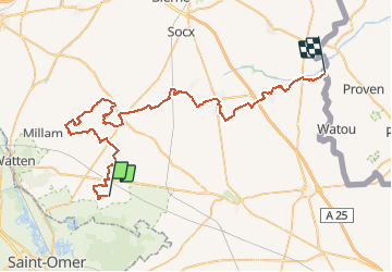
Trail Walking of 55 km to be discovered at Hauts-de-France, Nord, Buysscheure. This trail is proposed by Lecoester.
Description
Gr 130 de Buysscheure au quatre extrémités (frontière belge).
Aprés Herzeele avant de traverser le Ruisseau d'Herzeele, possibilité de prendre à gauche pour faire la variante qui mène à Oost-Cappel en passant par Bambecque
Positioning
Country:
France
Region :
Hauts-de-France
Department/Province :
Nord
Municipality :
Buysscheure
Location:
Unknown
Start:(Dec)
Start:(UTM)
453028 ; 5628214 (31U) N.
Comments
Trails nearby
![Trail Walking Clairmarais - Clairmarai - Photo](https://media.geolcdn.com/t/375/260/ext.jpg?maxdim=2&url=https%3A%2F%2Fmedia.geolcdn.com%2Ff%2Fc4bf9804-18b1-4dab-b334-d961028280c1.jpg)
![Walking Walking](https://static1.geolcdn.com/sitytour/trail-icons/101.png)
Clairmarai
Walking
Difficult
(1)
Clairmarais,
Hauts-de-France,
Pas-de-Calais,
France
![](/images/other/stat-length.png)
19.6 km | 21 km-effort
5h 8min
![](https://static1.geolcdn.com/siteimages/upload/files/16400158638029165_repeat_loop_refresh_sync_direction_icon.png)
No
![Trail Walking Nieurlet - Circuit de Booneghem -Nieurlet - Photo](https://media.geolcdn.com/t/375/260/ext.jpg?maxdim=2&url=https%3A%2F%2Fservices.sitytrail.com%2FGeolivesWS%2FDownloadMedia.ashx%3FTrailID%3D110280%26Media%3D5674_6.jpg)
![Walking Walking](https://static1.geolcdn.com/sitytour/trail-icons/101.png)
Circuit de Booneghem -Nieurlet
Walking
Medium
(1)
Nieurlet,
Hauts-de-France,
Nord,
France
![](/images/other/stat-length.png)
9.6 km | 10.1 km-effort
2h 30min
![](https://static1.geolcdn.com/siteimages/upload/files/16400158638029165_repeat_loop_refresh_sync_direction_icon.png)
Yes
![Trail Walking Buysscheure - Vers le paradis - Photo](https://media.geolcdn.com/t/375/260/ext.jpg?maxdim=2&url=https%3A%2F%2Fservices.sitytrail.com%2FGeolivesWS%2FDownloadMedia.ashx%3FTrailID%3D202854%26Media%3Dc89a9bf4-b065-43b0-ae31-88906460cb64.jpg)
![Walking Walking](https://static1.geolcdn.com/sitytour/trail-icons/101.png)
Vers le paradis
Walking
Very easy
(1)
Buysscheure,
Hauts-de-France,
Nord,
France
![](/images/other/stat-length.png)
7.1 km | 7.8 km-effort
Unknown
![](https://static1.geolcdn.com/siteimages/upload/files/16400158638029165_repeat_loop_refresh_sync_direction_icon.png)
Yes
![Trail sport Clairmarais - À la découverte du marais audomarois - Photo](https://media.geolcdn.com/t/375/260/ext.jpg?maxdim=2&url=https%3A%2F%2Fsecurestorage.geolives.com%2Fsitytour%2Ftrail-bg%2Fdefault.jpg)
À la découverte du marais audomarois
sport
Very easy
(1)
Clairmarais,
Hauts-de-France,
Pas-de-Calais,
France
![](/images/other/stat-length.png)
6.8 km | 7.2 km-effort
Unknown
![](https://static1.geolcdn.com/siteimages/upload/files/16400158638029165_repeat_loop_refresh_sync_direction_icon.png)
Yes
![Trail On foot Clairmarais - activity_1282864488 - Photo](https://media.geolcdn.com/t/375/260/ext.jpg?maxdim=2&url=https%3A%2F%2Fmedia.geolcdn.com%2Ff%2Fda976e2f-30a1-4830-854a-07f83bce2d98.JPG)
![On foot On foot](https://static1.geolcdn.com/sitytour/trail-icons/100.png)
activity_1282864488
On foot
Medium
Clairmarais,
Hauts-de-France,
Pas-de-Calais,
France
![](/images/other/stat-length.png)
14.9 km | 16.1 km-effort
3h 59min
![](https://static1.geolcdn.com/siteimages/upload/files/16400158638029165_repeat_loop_refresh_sync_direction_icon.png)
Yes
![Trail Walking Nieurlet - Circuit de Booneghem - Photo](https://media.geolcdn.com/t/375/260/ext.jpg?maxdim=2&url=https%3A%2F%2Fservices.sitytrail.com%2FGeolivesWS%2FDownloadMedia.ashx%3FTrailID%3D202880%26Media%3D84647b9b-d5cd-471e-a635-5cc71dd11283.jpg)
![Walking Walking](https://static1.geolcdn.com/sitytour/trail-icons/101.png)
Circuit de Booneghem
Walking
Very easy
Nieurlet,
Hauts-de-France,
Nord,
France
![](/images/other/stat-length.png)
8.6 km | 9.1 km-effort
Unknown
![](https://static1.geolcdn.com/siteimages/upload/files/16400158638029165_repeat_loop_refresh_sync_direction_icon.png)
Yes
![Trail Walking Clairmarais - copie - Photo](https://media.geolcdn.com/t/375/260/ext.jpg?maxdim=2&url=https%3A%2F%2Fservices.sitytrail.com%2FGeolivesWS%2FDownloadMedia.ashx%3FTrailID%3D154799%26Media%3D20120922125651.jpeg)
![Walking Walking](https://static1.geolcdn.com/sitytour/trail-icons/101.png)
copie
Walking
Easy
Clairmarais,
Hauts-de-France,
Pas-de-Calais,
France
![](/images/other/stat-length.png)
8.1 km | 8.5 km-effort
2h 4min
![](https://static1.geolcdn.com/siteimages/upload/files/16400158638029165_repeat_loop_refresh_sync_direction_icon.png)
Yes
![Trail Cycle Volckerinckhove - Boucle de Volckerinckhove - Photo](https://media.geolcdn.com/t/375/260/ext.jpg?maxdim=2&url=https%3A%2F%2Fservices.sitytrail.com%2FGeolivesWS%2FDownloadMedia.ashx%3FTrailID%3D118850%26Media%3D13063_6.jpg)
![Cycle Cycle](https://static1.geolcdn.com/sitytour/trail-icons/200.png)
Boucle de Volckerinckhove
Cycle
Easy
Volckerinckhove,
Hauts-de-France,
Nord,
France
![](/images/other/stat-length.png)
29 km | 31 km-effort
1h 30min
![](https://static1.geolcdn.com/siteimages/upload/files/16400158638029165_repeat_loop_refresh_sync_direction_icon.png)
Yes
![Trail Walking Buysscheure - Vers le Paradis - Buysscheure - Photo](https://media.geolcdn.com/t/375/260/ext.jpg?maxdim=2&url=https%3A%2F%2Fservices.sitytrail.com%2FGeolivesWS%2FDownloadMedia.ashx%3FTrailID%3D111846%26Media%3D8607_6.jpg)
![Walking Walking](https://static1.geolcdn.com/sitytour/trail-icons/101.png)
Vers le Paradis - Buysscheure
Walking
Medium
Buysscheure,
Hauts-de-France,
Nord,
France
![](/images/other/stat-length.png)
7.8 km | 8.6 km-effort
2h 0min
![](https://static1.geolcdn.com/siteimages/upload/files/16400158638029165_repeat_loop_refresh_sync_direction_icon.png)
Yes