


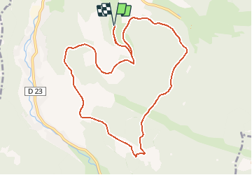
Tour du Bramont - Plainfaing

B0uille
User

Length
10.5 km

Max alt
936 m

Uphill gradient
380 m
Km-Effort
15.6 km

Min alt
652 m

Downhill gradient
380 m
Boucle
Yes
Creation date :
2016-05-09 00:00:00.0
Updated on :
2016-05-09 00:00:00.0
2h30
Difficulty : Medium

FREE GPS app for hiking
 SityTrail
IGN / Geographical institutes
SityTrail Plus
The world is yours!
About
Trail Walking of 10.5 km to be discovered at Grand Est, Vosges, Plainfaing. This trail is proposed by B0uille.
Positioning
Country:
France
Region :
Grand Est
Department/Province :
Vosges
Municipality :
Plainfaing
Location:
Unknown
Start:(Dec)
Start:(UTM)
353394 ; 5336291 (32U) N.
Comments