


Le lac blanc - Soultzeren Eck - Gazon du Faing

B0uille
User
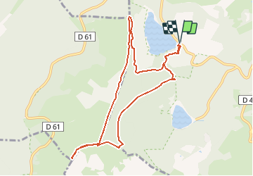

Length
9.5 km

Max alt
1304 m

Uphill gradient
395 m
Km-Effort
14.8 km

Min alt
1053 m

Downhill gradient
395 m
Boucle
Yes
Creation date :
2016-03-10 00:00:00.0
Updated on :
2016-03-10 00:00:00.0
3h11
Difficulty : Medium

FREE GPS app for hiking
 SityTrail
IGN / Geographical institutes
SityTrail Plus
The world is yours!
About
Trail Walking of 9.5 km to be discovered at Grand Est, Haut-Rhin, Orbey. This trail is proposed by B0uille.


Positioning
Country:
France
Region :
Grand Est
Department/Province :
Haut-Rhin
Municipality :
Orbey
Location:
Unknown
Start:(Dec)
Start:(UTM)
358360 ; 5331964 (32U) N.
Comments