


montstromain

jpfrobert
User
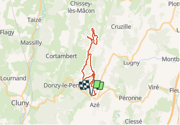

Length
23 km

Max alt
556 m

Uphill gradient
632 m
Km-Effort
32 km

Min alt
259 m

Downhill gradient
630 m
Boucle
Yes
Creation date :
2016-03-13 00:00:00.0
Updated on :
2016-03-13 00:00:00.0
2h03
Difficulty : Medium

FREE GPS app for hiking
 SityTrail
IGN / Geographical institutes
SityTrail Plus
The world is yours!
About
Trail Mountain bike of 23 km to be discovered at Bourgogne-Franche-Comté, Saône-et-Loire, Azé. This trail is proposed by jpfrobert.
Positioning
Country:
France
Region :
Bourgogne-Franche-Comté
Department/Province :
Saône-et-Loire
Municipality :
Azé
Location:
Unknown
Start:(Dec)
Start:(UTM)
634916 ; 5144471 (31T) N.
Comments