


audresselles- le cap gris nez

lepompi
User
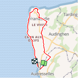

Length
12.1 km

Max alt
61 m

Uphill gradient
161 m
Km-Effort
14.3 km

Min alt
7 m

Downhill gradient
165 m
Boucle
Yes
Creation date :
2016-03-14 00:00:00.0
Updated on :
2018-10-13 16:38:57.772
3h06
Difficulty : Unknown

FREE GPS app for hiking
 SityTrail
IGN / Geographical institutes
SityTrail Plus
The world is yours!
About
Trail Walking of 12.1 km to be discovered at Hauts-de-France, Pas-de-Calais, Audresselles. This trail is proposed by lepompi.
Description
audresselles
Positioning
Country:
France
Region :
Hauts-de-France
Department/Province :
Pas-de-Calais
Municipality :
Audresselles
Location:
Unknown
Start:(Dec)
Start:(UTM)
400890 ; 5631518 (31U) N.
Comments