


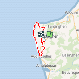
Audinghen Sentier des Crans

pjjrevrard
User

Length
15.1 km

Max alt
68 m

Uphill gradient
192 m
Km-Effort
17.7 km

Min alt
7 m

Downhill gradient
192 m
Boucle
Yes
Creation date :
2016-03-16 00:00:00.0
Updated on :
2016-03-16 00:00:00.0
3h53
Difficulty : Medium

FREE GPS app for hiking
 SityTrail
IGN / Geographical institutes
SityTrail Plus
The world is yours!
About
Trail Walking of 15.1 km to be discovered at Hauts-de-France, Pas-de-Calais, Audinghen. This trail is proposed by pjjrevrard.
Positioning
Country:
France
Region :
Hauts-de-France
Department/Province :
Pas-de-Calais
Municipality :
Audinghen
Location:
Unknown
Start:(Dec)
Start:(UTM)
401823 ; 5633584 (31U) N.
Comments
Circuit très agréable, très sympa le long des falaises...