


VAE, mer, montagne, pistes, routes

rene06530
User


3h33
Difficulty : Medium

FREE GPS app for hiking
 SityTrail
IGN / Geographical institutes
SityTrail Plus
The world is yours!
About
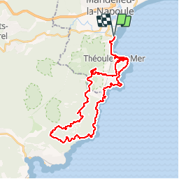
Trail Mountain bike of 39 km to be discovered at Provence-Alpes-Côte d'Azur, Maritime Alps, Mandelieu-la-Napoule. This trail is proposed by rene06530.
Description
Départ Mandelieu la Napoule, notre dame d'Afrique, Col de théoule, collet des monges,col notre dame, col de l'eveque, St Baume, carrefour du Mourrefrey, rocher St Baarthelemy, D569, Mandelieu.
Positioning
Comments