


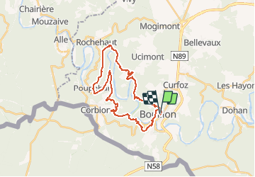
Bouillon, Corbion Rochehaut Botassard L'épine Belvédère Bouillon

ramagufa
User

Length
27 km

Max alt
376 m

Uphill gradient
949 m
Km-Effort
39 km

Min alt
194 m

Downhill gradient
950 m
Boucle
Yes
Creation date :
2019-04-16 19:16:39.277
Updated on :
2020-06-12 15:53:27.972
8h09
Difficulty : Difficult

FREE GPS app for hiking
 SityTrail
IGN / Geographical institutes
SityTrail Plus
The world is yours!
About
Trail Walking of 27 km to be discovered at Wallonia, Luxembourg, Bouillon. This trail is proposed by ramagufa.
Positioning
Country:
Belgium
Region :
Wallonia
Department/Province :
Luxembourg
Municipality :
Bouillon
Location:
Bouillon
Start:(Dec)
Start:(UTM)
648979 ; 5517937 (31U) N.
Comments
top.
Jolie trace, qui intègre les points à voir. N’a pas peur du d+. Fait en 3h05. Très boisé, joueur. Vraiment bien.