


VAE, esterel, lac écureuil.

rene06530
User
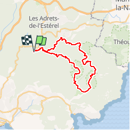

Length
29 km

Max alt
469 m

Uphill gradient
639 m
Km-Effort
38 km

Min alt
27 m

Downhill gradient
628 m
Boucle
Yes
Creation date :
2016-12-03 00:00:00.0
Updated on :
2016-12-03 00:00:00.0
2h29
Difficulty : Medium

FREE GPS app for hiking
 SityTrail
IGN / Geographical institutes
SityTrail Plus
The world is yours!
About
Trail Mountain bike of 29 km to be discovered at Provence-Alpes-Côte d'Azur, Var, Fréjus. This trail is proposed by rene06530.
Description
VAE,Malpey, aire de l'olivier,
Col du mistral par piste du perthus, col de belle barbe,lac de l'écureuil, col des suvières,baisse violette, aire de l'olivier, Malpey
Positioning
Country:
France
Region :
Provence-Alpes-Côte d'Azur
Department/Province :
Var
Municipality :
Fréjus
Location:
Unknown
Start:(Dec)
Start:(UTM)
322272 ; 4818219 (32T) N.
Comments