


mt férion

sylvainstaels
User
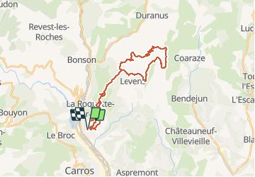

Length
33 km

Max alt
1399 m

Uphill gradient
1357 m
Km-Effort
51 km

Min alt
180 m

Downhill gradient
1358 m
Boucle
Yes
Creation date :
2016-03-26 00:00:00.0
Updated on :
2016-03-26 00:00:00.0
3h18
Difficulty : Medium

FREE GPS app for hiking
 SityTrail
IGN / Geographical institutes
SityTrail Plus
The world is yours!
About
Trail Mountain bike of 33 km to be discovered at Provence-Alpes-Côte d'Azur, Maritime Alps, Saint-Martin-du-Var. This trail is proposed by sylvainstaels.
Positioning
Country:
France
Region :
Provence-Alpes-Côte d'Azur
Department/Province :
Maritime Alps
Municipality :
Saint-Martin-du-Var
Location:
Unknown
Start:(Dec)
Start:(UTM)
354974 ; 4852703 (32T) N.
Comments