


14 chateau dormans rive droite

bruno38
User

Length
30 km

Max alt
171 m

Uphill gradient
477 m
Km-Effort
37 km

Min alt
57 m

Downhill gradient
470 m
Boucle
No
Creation date :
2017-03-21 00:00:00.0
Updated on :
2017-03-21 00:00:00.0
6h34
Difficulty : Very difficult

FREE GPS app for hiking
 SityTrail
IGN / Geographical institutes
SityTrail Plus
The world is yours!
About
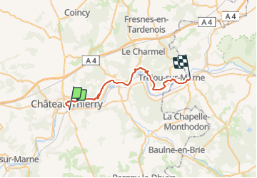
Trail Other activity of 30 km to be discovered at Hauts-de-France, Aisne, Château-Thierry. This trail is proposed by bruno38.
Positioning
Country:
France
Region :
Hauts-de-France
Department/Province :
Aisne
Municipality :
Château-Thierry
Location:
Unknown
Start:(Dec)
Start:(UTM)
529875 ; 5431747 (31U) N.
Comments