


sortie montat 04

cps46
User
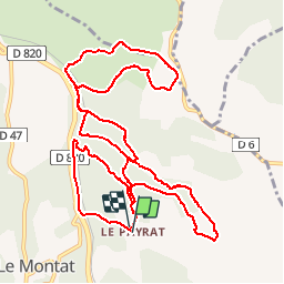

Length
14 km

Max alt
271 m

Uphill gradient
348 m
Km-Effort
18.6 km

Min alt
168 m

Downhill gradient
350 m
Boucle
Yes
Creation date :
2016-04-02 00:00:00.0
Updated on :
2016-04-02 00:00:00.0
1h57
Difficulty : Unknown

FREE GPS app for hiking
 SityTrail
IGN / Geographical institutes
SityTrail Plus
The world is yours!
About
Trail Mountain bike of 14 km to be discovered at Occitania, Lot, Le Montat. This trail is proposed by cps46.
Positioning
Country:
France
Region :
Occitania
Department/Province :
Lot
Municipality :
Le Montat
Location:
Unknown
Start:(Dec)
Start:(UTM)
377407 ; 4915627 (31T) N.
Comments