sur la crête entre Gorze et le Rudémont

jeanlucLOHIER
User
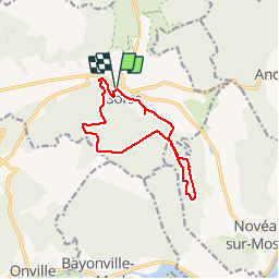

Length
11.4 km

Max alt
352 m

Uphill gradient
259 m
Km-Effort
14.9 km

Min alt
200 m

Downhill gradient
262 m
Boucle
Yes
Creation date :
2016-04-09 00:00:00.0
Updated on :
2016-04-09 00:00:00.0
2h39
Difficulty : Medium

FREE GPS app for hiking
 SityTrail
IGN / Geographical institutes
SityTrail Plus
The world is yours!
About
Trail Walking of 11.4 km to be discovered at Grand Est, Moselle, Gorze. This trail is proposed by jeanlucLOHIER.
Description
repérage traces vtt
Positioning
Country:
France
Region :
Grand Est
Department/Province :
Moselle
Municipality :
Gorze
Location:
Unknown
Start:(Dec)
Start:(UTM)
718978 ; 5437726 (31U) N.
Comments