


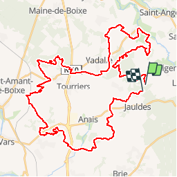
rando jauldes

ludol
User

Length
56 km

Max alt
151 m

Uphill gradient
682 m
Km-Effort
65 km

Min alt
61 m

Downhill gradient
679 m
Boucle
No
Creation date :
2016-04-10 00:00:00.0
Updated on :
2016-04-10 00:00:00.0
3h30
Difficulty : Medium

FREE GPS app for hiking
 SityTrail
IGN / Geographical institutes
SityTrail Plus
The world is yours!
About
Trail Mountain bike of 56 km to be discovered at New Aquitaine, Charente, Jauldes. This trail is proposed by ludol.
Description
Rando club
Positioning
Country:
France
Region :
New Aquitaine
Department/Province :
Charente
Municipality :
Jauldes
Location:
Unknown
Start:(Dec)
Start:(UTM)
287547 ; 5075376 (31T) N.
Comments