


col de lastris depuis lapege

petit-pied
User
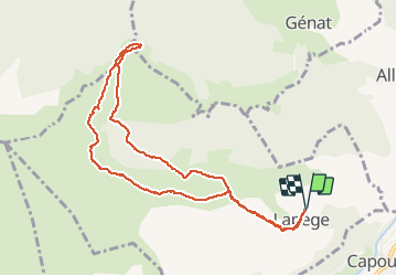

Length
11.1 km

Max alt
1511 m

Uphill gradient
570 m
Km-Effort
18.7 km

Min alt
985 m

Downhill gradient
571 m
Boucle
Yes
Creation date :
2019-04-14 17:15:10.397
Updated on :
2019-04-14 17:15:10.482
6h10
Difficulty : Medium

FREE GPS app for hiking
 SityTrail
IGN / Geographical institutes
SityTrail Plus
The world is yours!
About
Trail Walking of 11.1 km to be discovered at Occitania, Ariège, Lapège. This trail is proposed by petit-pied.
Positioning
Country:
France
Region :
Occitania
Department/Province :
Ariège
Municipality :
Lapège
Location:
Unknown
Start:(Dec)
Start:(UTM)
383292 ; 4739809 (31T) N.
Comments