


chemin de la vuettaz

COMAN
User
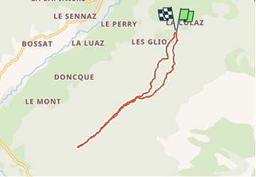

Length
6.8 km

Max alt
1304 m

Uphill gradient
284 m
Km-Effort
10.6 km

Min alt
1095 m

Downhill gradient
288 m
Boucle
Yes
Creation date :
2016-04-15 00:00:00.0
Updated on :
2016-04-15 00:00:00.0
2h23
Difficulty : Easy

FREE GPS app for hiking
 SityTrail
IGN / Geographical institutes
SityTrail Plus
The world is yours!
About
Trail Walking of 6.8 km to be discovered at Auvergne-Rhône-Alpes, Upper Savoy, Fillière. This trail is proposed by COMAN.


Positioning
Country:
France
Region :
Auvergne-Rhône-Alpes
Department/Province :
Upper Savoy
Municipality :
Fillière
Location:
Thorens-Glières
Start:(Dec)
Start:(UTM)
291098 ; 5099153 (32T) N.
Comments