


J2 Sancy

raphael94
User

Length
24 km

Max alt
1346 m

Uphill gradient
1010 m
Km-Effort
36 km

Min alt
862 m

Downhill gradient
620 m
Boucle
No
Creation date :
2016-04-12 00:00:00.0
Updated on :
2016-04-12 00:00:00.0
7h42
Difficulty : Unknown

FREE GPS app for hiking
 SityTrail
IGN / Geographical institutes
SityTrail Plus
The world is yours!
About
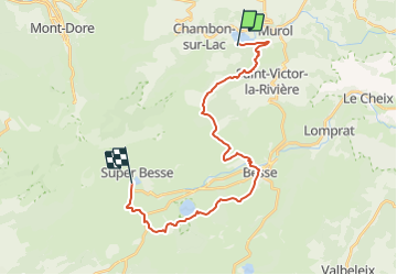
Trail Walking of 24 km to be discovered at Auvergne-Rhône-Alpes, Puy-de-Dôme, Chambon-sur-Lac. This trail is proposed by raphael94.
Positioning
Country:
France
Region :
Auvergne-Rhône-Alpes
Department/Province :
Puy-de-Dôme
Municipality :
Chambon-sur-Lac
Location:
Unknown
Start:(Dec)
Start:(UTM)
493670 ; 5046009 (31T) N.
Comments