


Essars 8.2 km

Blourouce
User
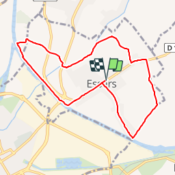

Length
8.2 km

Max alt
24 m

Uphill gradient
36 m
Km-Effort
8.7 km

Min alt
15 m

Downhill gradient
36 m
Boucle
Yes
Creation date :
2019-01-12 16:54:25.614
Updated on :
2019-01-12 16:54:25.622
1h56
Difficulty : Easy

FREE GPS app for hiking
 SityTrail
IGN / Geographical institutes
SityTrail Plus
The world is yours!
About
Trail Walking of 8.2 km to be discovered at Hauts-de-France, Pas-de-Calais, Essars. This trail is proposed by Blourouce.
Positioning
Country:
France
Region :
Hauts-de-France
Department/Province :
Pas-de-Calais
Municipality :
Essars
Location:
Unknown
Start:(Dec)
Start:(UTM)
476297 ; 5599591 (31U) N.
Comments