


69620_Létra-160413_notre Dame Salette

adye
User
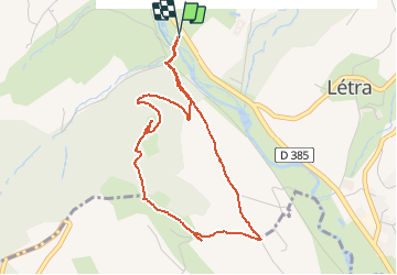

Length
4.5 km

Max alt
479 m

Uphill gradient
193 m
Km-Effort
7.1 km

Min alt
291 m

Downhill gradient
192 m
Boucle
Yes
Creation date :
2016-04-13 00:00:00.0
Updated on :
2016-04-13 00:00:00.0
1h27
Difficulty : Medium

FREE GPS app for hiking
 SityTrail
IGN / Geographical institutes
SityTrail Plus
The world is yours!
About
Trail Walking of 4.5 km to be discovered at Auvergne-Rhône-Alpes, Rhône, Létra. This trail is proposed by adye.
Description
montée à Notre Dame de la Salette. Joli panorama sur Létra, Oingt, ... Sentier caillouteux.
Positioning
Country:
France
Region :
Auvergne-Rhône-Alpes
Department/Province :
Rhône
Municipality :
Létra
Location:
Unknown
Start:(Dec)
Start:(UTM)
617063 ; 5091257 (31T) N.
Comments