


rots Masson 11,5 kms

aubinjoel
User
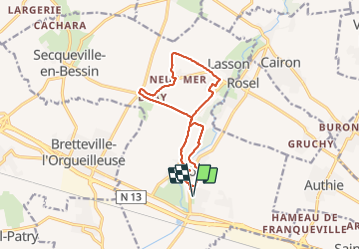

Length
12.2 km

Max alt
64 m

Uphill gradient
75 m
Km-Effort
13.2 km

Min alt
41 m

Downhill gradient
75 m
Boucle
Yes
Creation date :
2016-04-13 00:00:00.0
Updated on :
2016-04-13 00:00:00.0
2h56
Difficulty : Easy

FREE GPS app for hiking
 SityTrail
IGN / Geographical institutes
SityTrail Plus
The world is yours!
About
Trail Nordic walking of 12.2 km to be discovered at Normandy, Calvados, Rots. This trail is proposed by aubinjoel.
Description
Rots Masson 11kms5
Positioning
Country:
France
Region :
Normandy
Department/Province :
Calvados
Municipality :
Rots
Location:
Rots
Start:(Dec)
Start:(UTM)
683837 ; 5453184 (30U) N.
Comments