


Croix Scaille et Fagne de l'abîme

ramagufa
User
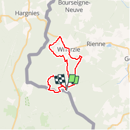

Length
22 km

Max alt
504 m

Uphill gradient
438 m
Km-Effort
27 km

Min alt
307 m

Downhill gradient
438 m
Boucle
Yes
Creation date :
2019-04-16 19:16:38.13
Updated on :
2019-04-16 19:16:38.168
5h50
Difficulty : Medium

FREE GPS app for hiking
 SityTrail
IGN / Geographical institutes
SityTrail Plus
The world is yours!
About
Trail Walking of 22 km to be discovered at Wallonia, Namur, Gedinne. This trail is proposed by ramagufa.
Positioning
Country:
Belgium
Region :
Wallonia
Department/Province :
Namur
Municipality :
Gedinne
Location:
Bourseigne-Neuve
Start:(Dec)
Start:(UTM)
632355 ; 5534850 (31U) N.
Comments