


Labeaume Chapias

csy95
User
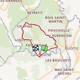

Length
11.2 km

Max alt
278 m

Uphill gradient
261 m
Km-Effort
14.7 km

Min alt
114 m

Downhill gradient
262 m
Boucle
Yes
Creation date :
2018-08-26 10:57:51.117
Updated on :
2018-08-26 10:57:51.433
3h24
Difficulty : Easy

FREE GPS app for hiking
 SityTrail
IGN / Geographical institutes
SityTrail Plus
The world is yours!
About
Trail Walking of 11.2 km to be discovered at Auvergne-Rhône-Alpes, Ardèche, Labeaume. This trail is proposed by csy95.
Description
a travers les terrasses.
Positioning
Country:
France
Region :
Auvergne-Rhône-Alpes
Department/Province :
Ardèche
Municipality :
Labeaume
Location:
Unknown
Start:(Dec)
Start:(UTM)
603898 ; 4922473 (31T) N.
Comments