Trail Walking Gy-les-Nonains - Gy-les-nonains - Photo
© OpenStreetMap contributors
Length
Length
11.6 km
Max alt
Max alt
144 m
Uphill gradient
Uphill gradient
103 m
Km-Effort
Km-Effort  
13 km
Min alt
Min alt
101 m
Downhill gradient
Downhill gradient
102 m
Boucle
Boucle
Yes
Creation date :
2019-05-03 09:15:11.561
Updated on :
2019-05-03 09:15:11.626

(0 Reviews)

Walking
Walking
2h52
Difficulty : Easy

Scan this QR Code to open this trail in the SityTrail application

FREE GPS app for hiking

Logo SityTrail SityTrail

IGN / Geographical institutes

Download SityTrail from the App Store Download SityTrail from Google Play

Logo SityTrail SityTrail World

The world is yours!

Download SityTrail from the App Store Download SityTrail from Google Play Download SityTrail on Huawei AppGallery

About

Trail Walking of 11.6 km to be discovered at Centre-Loire Valley, Loiret, Gy-les-Nonains. This trail is proposed by Ordijamo45.

Description

Départ du Parking de l'église de Gy*les-Nonains

Elevation profile

Positioning

Country:
France
Region :
Centre-Loire Valley
Department/Province :
Loiret
Municipality :
Gy-les-Nonains
Location:
Unknown
Start:(UTM)
488920 ; 5310452 (31T) N.

Trails nearby

Trail Nordic walking Conflans-sur-Loing - Conflans sur loing - Photo
Nordic walking
picouleau220345

Nordic walking

Medium
Conflans-sur-Loing, Centre-Loire Valley, Loiret, France
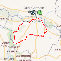
10.8 km | 12.6 km-effort
2h 59min
Yes
Trail Walking Montcresson - L'orme au Muet - Photo
Walking
Ordijamo45

Walking

Easy
Montcresson, Centre-Loire Valley, Loiret, France
11.2 km | 12.3 km-effort
1h 52min
Yes
Trail Walking Saint-Germain-des-Prés - saint Germain des Prés  - Photo
Walking
picouleau220345

Walking

Difficult
Saint-Germain-des-Prés, Centre-Loire Valley, Loiret, France
11.7 km | 13 km-effort
3h 6min
Yes
Trail Walking Montcresson - montcresson 45 - Photo
Walking
picouleau220345

Walking

Difficult
Montcresson, Centre-Loire Valley, Loiret, France
11.9 km | 13.5 km-effort
3h 2min
No
Trail Walking Conflans-sur-Loing - Conflan sur loing 45 - Photo
Walking
picouleau220345

Walking

Difficult
Conflans-sur-Loing, Centre-Loire Valley, Loiret, France
10.9 km | 12.6 km-effort
2h 44min
Yes
Trail Walking Conflans-sur-Loing - Conflans sur Loing 45 6km2 - Photo
Walking
picouleau220345

Walking

Easy
Conflans-sur-Loing, Centre-Loire Valley, Loiret, France
6.2 km | 7.2 km-effort
2h 1min
Yes
Trail Walking Montcresson - Pr de la vallée du Loing - Photo
Walking
Ordijamo45

Walking

Easy
Montcresson, Centre-Loire Valley, Loiret, France
13.2 km | 14.3 km-effort
3h 10min
Yes
Trail Mountain bike Conflans-sur-Loing - Rando du 15 aout 2008 - Conflans sur Loing - Photo
Mountain bike
tracegps

Mountain bike

Medium
(1)
Conflans-sur-Loing, Centre-Loire Valley, Loiret, France
41 km | 47 km-effort
2h 30min
Yes
Trail Walking Saint-Germain-des-Prés - La Galisonne - Photo
Walking
Ordijamo45

Walking

Easy
Saint-Germain-des-Prés, Centre-Loire Valley, Loiret, France
9.4 km | 10.7 km-effort
2h 25min
Yes


Close
My subscriptions