


tandounet laburgade 2

cps46
User
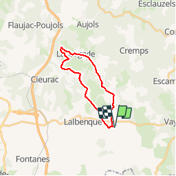

Length
19.9 km

Max alt
288 m

Uphill gradient
285 m
Km-Effort
24 km

Min alt
204 m

Downhill gradient
285 m
Boucle
Yes
Creation date :
2016-04-28 00:00:00.0
Updated on :
2016-04-28 00:00:00.0
1h39
Difficulty : Unknown

FREE GPS app for hiking
 SityTrail
IGN / Geographical institutes
SityTrail Plus
The world is yours!
About
Trail Mountain bike of 19.9 km to be discovered at Occitania, Lot, Lalbenque. This trail is proposed by cps46.
Positioning
Country:
France
Region :
Occitania
Department/Province :
Lot
Municipality :
Lalbenque
Location:
Unknown
Start:(Dec)
Start:(UTM)
386709 ; 4909876 (31T) N.
Comments