


monslacon

whisper73
User
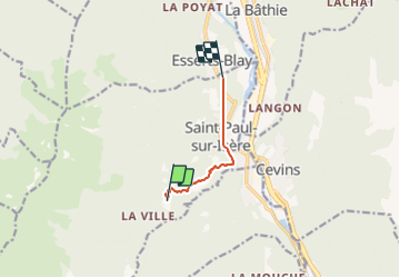

Length
5 km

Max alt
1117 m

Uphill gradient
128 m
Km-Effort
8.8 km

Min alt
407 m

Downhill gradient
754 m
Boucle
No
Creation date :
2016-04-30 00:00:00.0
Updated on :
2016-04-30 00:00:00.0
1h01
Difficulty : Medium

FREE GPS app for hiking
 SityTrail
IGN / Geographical institutes
SityTrail Plus
The world is yours!
About
Trail Other activity of 5 km to be discovered at Auvergne-Rhône-Alpes, Savoy, Saint-Paul-sur-Isère. This trail is proposed by whisper73.
Positioning
Country:
France
Region :
Auvergne-Rhône-Alpes
Department/Province :
Savoy
Municipality :
Saint-Paul-sur-Isère
Location:
Unknown
Start:(Dec)
Start:(UTM)
298867 ; 5051022 (32T) N.
Comments