


Etretat

Djaie60
User
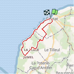

Length
10 km

Max alt
106 m

Uphill gradient
267 m
Km-Effort
13.5 km

Min alt
4 m

Downhill gradient
264 m
Boucle
Yes
Creation date :
2019-04-12 07:41:48.207
Updated on :
2019-05-01 14:28:12.676
2h52
Difficulty : Difficult

FREE GPS app for hiking
 SityTrail
IGN / Geographical institutes
SityTrail Plus
The world is yours!
About
Trail Walking of 10 km to be discovered at Normandy, Seine-Maritime, Étretat. This trail is proposed by Djaie60.
Positioning
Country:
France
Region :
Normandy
Department/Province :
Seine-Maritime
Municipality :
Étretat
Location:
Unknown
Start:(Dec)
Start:(UTM)
298238 ; 5509868 (31U) N.
Comments