


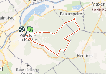
Claudine Verneuil en Halatte

Francine
User

Length
13.3 km

Max alt
122 m

Uphill gradient
222 m
Km-Effort
16.3 km

Min alt
32 m

Downhill gradient
220 m
Boucle
Yes
Creation date :
2016-05-07 00:00:00.0
Updated on :
2016-05-07 00:00:00.0
3h30
Difficulty : Difficult

FREE GPS app for hiking
 SityTrail
IGN / Geographical institutes
SityTrail Plus
The world is yours!
About
Trail Walking of 13.3 km to be discovered at Hauts-de-France, Oise, Verneuil-en-Halatte. This trail is proposed by Francine.
Description
Verneuil en Halatte
Positioning
Country:
France
Region :
Hauts-de-France
Department/Province :
Oise
Municipality :
Verneuil-en-Halatte
Location:
Unknown
Start:(Dec)
Start:(UTM)
464895 ; 5458122 (31U) N.
Comments