


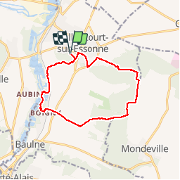
2016-05-11 Rando Ballancourt

jchezlemas
User

Length
12.6 km

Max alt
151 m

Uphill gradient
165 m
Km-Effort
14.8 km

Min alt
49 m

Downhill gradient
165 m
Boucle
Yes
Creation date :
2016-05-11 00:00:00.0
Updated on :
2016-05-11 00:00:00.0
3h14
Difficulty : Easy

FREE GPS app for hiking
 SityTrail
IGN / Geographical institutes
SityTrail Plus
The world is yours!
About
Trail Walking of 12.6 km to be discovered at Ile-de-France, Essonne, Ballancourt-sur-Essonne. This trail is proposed by jchezlemas.
Positioning
Country:
France
Region :
Ile-de-France
Department/Province :
Essonne
Municipality :
Ballancourt-sur-Essonne
Location:
Unknown
Start:(Dec)
Start:(UTM)
454230 ; 5374557 (31U) N.
Comments