Trail Walking Loubeyrat - Quatre routes - Étang de Laschamp  - Photo

Quatre routes - Étang de Laschamp

 Gegetop
Gegetop

User

© OpenStreetMap contributors
Length
Length
15.8 km
Max alt
Max alt
837 m
Uphill gradient
Uphill gradient
355 m
Km-Effort
Km-Effort  
21 km
Min alt
Min alt
673 m
Downhill gradient
Downhill gradient
356 m
Boucle
Boucle
Yes
Creation date :
2016-05-13 00:00:00.0
Updated on :
2016-05-13 00:00:00.0

(0 Reviews)

Walking
Walking
3h35
Difficulty : Medium

Scan this QR Code to open this trail in the SityTrail application

FREE GPS app for hiking

Logo SityTrail SityTrail

IGN / Geographical institutes

Download SityTrail from the App Store Download SityTrail from Google Play

Logo SityTrail SityTrail Plus

The world is yours!

Download SityTrail from the App Store Download SityTrail from Google Play Download SityTrail on Huawei AppGallery

About

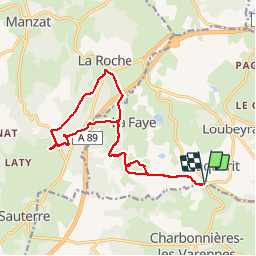
Trail Walking of 15.8 km to be discovered at Auvergne-Rhône-Alpes, Puy-de-Dôme, Loubeyrat. This trail is proposed by Gegetop.

Description

Départ quatre routes puis Rochebraud, La Faye haute, puis l'étang de Laschamp en franchissant l'autoroute par la passerelle. Retour par La Roche en franchissant l'autoroute par le tunnel puis retour sur nos traces.

Elevation profile

Positioning

Country:
France
Region :
Auvergne-Rhône-Alpes
Department/Province :
Puy-de-Dôme
Municipality :
Loubeyrat
Location:
Unknown
Start:(UTM)
500117 ; 5085464 (31T) N.


Close
My subscriptions