


cret de chalam en boucle

tgvpatrickfavre
User
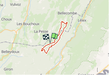

Length
20 km

Max alt
1522 m

Uphill gradient
768 m
Km-Effort
31 km

Min alt
1212 m

Downhill gradient
771 m
Boucle
Yes
Creation date :
2016-05-14 00:00:00.0
Updated on :
2016-05-14 00:00:00.0
6h23
Difficulty : Difficult

FREE GPS app for hiking
 SityTrail
IGN / Geographical institutes
SityTrail Plus
The world is yours!
About
Trail Walking of 20 km to be discovered at Bourgogne-Franche-Comté, Jura, La Pesse. This trail is proposed by tgvpatrickfavre.
Positioning
Country:
France
Region :
Bourgogne-Franche-Comté
Department/Province :
Jura
Municipality :
La Pesse
Location:
Unknown
Start:(Dec)
Start:(UTM)
721076 ; 5127679 (31T) N.
Comments