


vallee du rhodon

VMARTIN
User
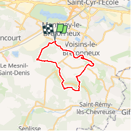

Length
21 km

Max alt
181 m

Uphill gradient
316 m
Km-Effort
25 km

Min alt
91 m

Downhill gradient
315 m
Boucle
Yes
Creation date :
2016-05-18 00:00:00.0
Updated on :
2016-05-18 00:00:00.0
5h21
Difficulty : Unknown

FREE GPS app for hiking
 SityTrail
IGN / Geographical institutes
SityTrail Plus
The world is yours!
About
Trail Walking of 21 km to be discovered at Ile-de-France, Yvelines, Montigny-le-Bretonneux. This trail is proposed by VMARTIN.
Positioning
Country:
France
Region :
Ile-de-France
Department/Province :
Yvelines
Municipality :
Montigny-le-Bretonneux
Location:
Unknown
Start:(Dec)
Start:(UTM)
427692 ; 5401871 (31U) N.
Comments
Tres beau circuit ombragé et beaux villages