


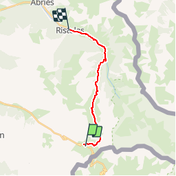
REFUGE AGNEL - RISTOLAS

bourel.jacques
User

Length
14 km

Max alt
2809 m

Uphill gradient
274 m
Km-Effort
21 km

Min alt
1610 m

Downhill gradient
1240 m
Boucle
No
Creation date :
2016-06-24 00:00:00.0
Updated on :
2016-06-24 00:00:00.0
3h53
Difficulty : Difficult

FREE GPS app for hiking
 SityTrail
IGN / Geographical institutes
SityTrail Plus
The world is yours!
About
Trail Walking of 14 km to be discovered at Provence-Alpes-Côte d'Azur, Hautes-Alpes, Molines-en-Queyras. This trail is proposed by bourel.jacques.
Description
Tour du Queyras - Etape 3
Positioning
Country:
France
Region :
Provence-Alpes-Côte d'Azur
Department/Province :
Hautes-Alpes
Municipality :
Molines-en-Queyras
Location:
Unknown
Start:(Dec)
Start:(UTM)
339261 ; 4950660 (32T) N.
Comments