


Vosges - Sentier des roches

mannequ1
User
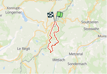

Length
15.6 km

Max alt
1355 m

Uphill gradient
927 m
Km-Effort
28 km

Min alt
922 m

Downhill gradient
934 m
Boucle
Yes
Creation date :
2016-05-16 00:00:00.0
Updated on :
2016-05-16 00:00:00.0
5h51
Difficulty : Medium

FREE GPS app for hiking
 SityTrail
IGN / Geographical institutes
SityTrail Plus
The world is yours!
About
Trail Walking of 15.6 km to be discovered at Grand Est, Haut-Rhin, Stosswihr. This trail is proposed by mannequ1.
Description
Sentier des roches - col entre les honeck - lac de Schiessrothried - Kastelberg - le honeck - Col de Falimont - col de la Schlucht
Physique (/10) : 6
Technique (/10) : 8
Positioning
Country:
France
Region :
Grand Est
Department/Province :
Haut-Rhin
Municipality :
Stosswihr
Location:
Unknown
Start:(Dec)
Start:(UTM)
352801 ; 5325260 (32U) N.
Comments